One of the immediate impacts of the Covid-19 pandemic was a realignment in where people choose to live and work. With the rise in remote work offerings, many relocated from dense urban centers to the suburbs and beyond, looking for more space and housing affordability. In addition to its lasting economic effects, this migration has begun to reshape the political makeup of these geographies.
At Data Trust, our mission is to produce the best political data on the market. To meet that mission and give our clients the tools they need to execute effective targeting programs, we are now providing enhanced intelligence on where your audience is and how that may affect their tendencies.
With the recent changes to our voter file schema, we are doing just that. Previously, the MetroType field on our voter file classified counties as either wholly urban or wholly rural. This was based on the Census Bureau’s definition of urban areas, with anything not meeting the urban criteria being grouped together as rural. This binary classification lacked the level of granularity and nuance that our clients require for this changing landscape. So, Data Trust is updating the way we define where voters live to improve client targeting capabilities.
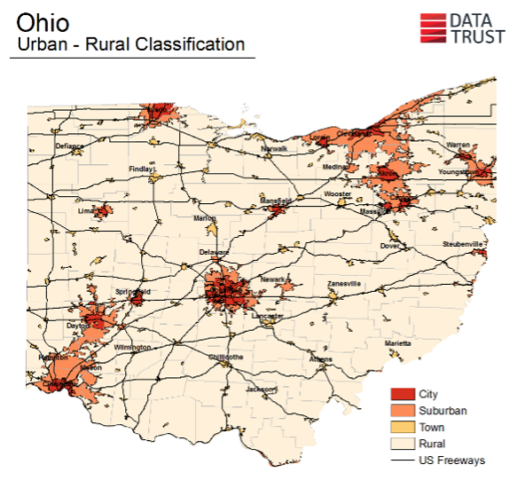
Today, using GIS products available from the National Center for Education Statistics (NCES), Data Trust is classifying each voter’s location in the MetroType field as either Urban, Suburban, Town, or Rural based on the census block in which they are registered. These classifications are defined as follows:
- Urban: Territory located within the portion of a Principal City, as designated by the Office of Management and Budget (OMB), that overlaps with a Census-designated Urbanized Area. Minimum population of 50,000.
- Suburban: Territory located inside a Census-designated Urbanized Area that is outside the boundary of a Principal City. Minimum population of 50,000.
- Town: Any territory located inside a Census-designated Urban Cluster. Population greater than or equal to 2,500 and less than 50,000.
- Rural: Any territory located inside a Census-designated Rural Area. Population less than 2,500
Rather than an urban/rural image of where voters are, this new lens shows us that 30.3% of voters are truly urban, 39.4% suburban, 8.3% town, and 21.9% rural. This brings the voter landscape into clearer focus.
The following map of Ohio helps to visualize the separation this new methodology established:
This improvement will enable valuable insights and more precise targeting for clients who rely on Data Trust’s best-in-class voter file as the foundation for their businesses.